|
|
Your HostI am Lorine McGinnis Schulze, creator of Olive Tree Genealogy and host of Victoria Co. GenWeb. My contact email is VictoriacogenwebATgmail.com I can't answer queries as I don't live in Victoria County but a great place to ask is the AskOliveTree blog where you can submit your Ontario genealogy challenges and brickwalls to me for help.
|
|
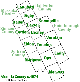
Victoria County was located in South-Eastern Ontario The County was established in 1851 from Peterborough County and named for Queen Victoria.
The area was first opened for settlement in 1821 and the first settlers arrived in 1825. They were Irish Protestants from County Fermanagh, Ireland. They were soon followed by other Irish & Scottish settlers. As with most counties, the southern part was settled first. In 1858 twelve new townships were added to Victoria County. In 1868 seven of the townships were removed from Victoria County (and attached to Muskoka District). In 2001, the county was merged with all of its constituent municipalities to form the City of Kawartha Lakes Former townships of Victoria County were Bexley, Carden, Dalton, Eldon, Emily, Fenelon, Laxton, Digby and Longford, Manvers, Mariposa, Ops, Somerville, Verulam. The 5 largest communities are: Omemee, Lindsay, Fenelon Falls, Woodville, and Bobcaygeon. The main population centers are: Omemee Lindsay Fenelon Falls Woodville Bobcaygeon |
|
MAPS
Map of Huron County from Historical Atlas
The County Atlas Digital Project is a searchable database of the property owners' names which appear on the township maps in the county atlases. Township maps, portraits and properties have been scanned, with links from the property owners' names in the database.
The County Atlas Digital Project is a searchable database of the property owners' names which appear on the township maps in the county atlases. Township maps, portraits and properties have been scanned, with links from the property owners' names in the database.
